| Hier finden Sie 215 Fotos / 22 Panoramen aus Bayern sowie Biketouren-Kurzbeschreibungen |
 |
| Touren-Beschreibungen (Kurz-Porträts) |
|
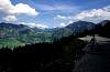
| Gebiet Berchtesgaden: Königssee, Hintersee |
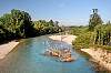
| Gebiet Bad Reichenhall: Saalachtal, Thumsee, Listsee ... |
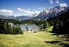
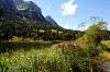
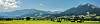
| Gebiet Garmisch-P.: Eibsee, Badersee, Lautersee, Ferchensee, Eckbauer, Geroldsee, Graswangtal, Loisachtal, Murnauer Moos ... |
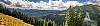
| Gebiet Sonthofen: Wittelsbacher Höhe, Hintersteinertal, Iller ... |
| Panoramen Gebiet Sonthofen |
| Osterseen |
| Benediktbeuern / Kochel |
|
|
|
|
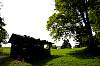
Biken in Bayern - bei Berchtesgaden |
|
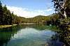
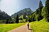
| Königsee / Hintersee bei Ramsau |

68.78 KB
520 x 800
|

104.28 KB
800 x 565
|

109.24 KB
800 x 561
|

82.49 KB
569 x 800
|

95.23 KB
565 x 800
|
|
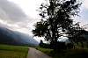
Biken in Bayern - bei Bad Reichenhall |
|
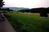
| Von Bad Reichenhall zum Thumsee ... |

374.78 KB
1024 x 680
|

368.25 KB
1024 x 680
|

391.80 KB
1024 x 680
|

365.04 KB
1024 x 680
|

352.13 KB
1024 x 680
|
| ... Listsee und zurück ... |

295.31 KB
1024 x 680
|

408.22 KB
1024 x 680
|

455.35 KB
1024 x 680
|

390.14 KB
1024 x 680
|

302.03 KB
1024 x 680
|

301.88 KB
1024 x 680
|

258.37 KB
1024 x 680
|
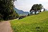
| Von Bad Reichenhall links und rechts der Saalach ... |

364.56 KB
1024 x 680
|

333.85 KB
1024 x 680
|

346.12 KB
1024 x 680
|

270.65 KB
1024 x 680
|
| ... bis zur österreichischen Grenze ... |

307.55 KB
1024 x 680
|

458.68 KB
1024 x 680
|

312.21 KB
1024 x 680
|
|
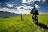
Biken in Bayern - bei Garmisch-Partenkirchen |
|
| Eibsee |

119.18 KB
547 x 800
|

131.30 KB
552 x 800
|

99.79 KB
555 x 800
|

129.76 KB
531 x 800
|

101.51 KB
531 x 800
|

118.08 KB
531 x 800
|

142.15 KB
531 x 800
|
81.31 KB
800 x 531
|

124.66 KB
800 x 531
|

109.39 KB
800 x 531
|

60.35 KB
800 x 531
|

118.53 KB
800 x 531
|

85.16 KB
800 x 531
|

48.57 KB
800 x 531
|

65.61 KB
800 x 531
|

114.21 KB
800 x 531
|

108.24 KB
800 x 531
|

109.65 KB
800 x 531
|

268.69 KB
1024 x 680
|

276.43 KB
1024 x 680
|

271.10 KB
1024 x 680
|

347.23 KB
1024 x 680
|

341.85 KB
1024 x 680
|

443.03 KB
644 x 1024
|

465.87 KB
1024 x 680
|

336.10 KB
1024 x 680
|

281.27 KB
1024 x 680
|

300.71 KB
1024 x 680
|

315.86 KB
1024 x 680
|
| Badersee |

79.91 KB
800 x 556
|

119.43 KB
800 x 531
|

118.82 KB
800 x 531
|

125.16 KB
800 x 531
|

99.60 KB
800 x 531
|

109.90 KB
800 x 531
|

308.83 KB
1024 x 680
|

177.41 KB
1024 x 680
|

364.45 KB
1024 x 680
|

421.36 KB
1024 x 680
|

449.45 KB
1024 x 680
|

386.43 KB
1024 x 680
|

379.06 KB
1024 x 680
|

277.37 KB
1024 x 680
|

348.31 KB
1024 x 680
|

325.14 KB
1024 x 680
|

391.18 KB
1024 x 680
|

161.76 KB
1024 x 680
|

376.01 KB
1024 x 680
|

284.49 KB
1024 x 680
|

185.95 KB
1024 x 680
|

404.91 KB
1024 x 680
|
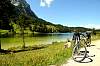
| Rundtour GAP, Mittenwald, Lauter-/Ferchensee, Hintergraseck, Graseck ... |

102.72 KB
800 x 531
|

80.81 KB
800 x 531
|

67.22 KB
800 x 531
|

81.90 KB
800 x 531
|
83.71 KB
800 x 553
|

73.80 KB
800 x 531
|

102.47 KB
800 x 531
|

110.54 KB
800 x 553
|

110.10 KB
800 x 552
|

77.98 KB
800 x 531
|

94.57 KB
800 x 531
|
91.79 KB
800 x 531
|

73.30 KB
800 x 531
|

86.34 KB
800 x 531
|

88.01 KB
800 x 531
|
111.89 KB
800 x 531
|

85.25 KB
800 x 531
|

142.40 KB
800 x 531
|

103.28 KB
800 x 531
|

63.58 KB
800 x 531
|

101.82 KB
800 x 552
|

72.69 KB
800 x 531
|

96.15 KB
800 x 531
|

94.29 KB
800 x 531
|

86.79 KB
800 x 554
|

21.67 KB
800 x 569
|

34.55 KB
800 x 559
|
| Beim Eckbauer (oberhalb Wamberg) |

90.41 KB
800 x 531
|

277.84 KB
1024 x 680
|

150.70 KB
1024 x 680
|
291.76 KB
1024 x 680
|
| Geroldsee |

89.18 KB
800 x 551
|

65.62 KB
800 x 531
|

60.47 KB
800 x 531
|

70.05 KB
800 x 531
|

107.89 KB
800 x 531
|

65.37 KB
800 x 531
|

69.37 KB
800 x 531
|

42.77 KB
800 x 531
|

95.20 KB
800 x 531
|
| Rundtour GAP - Graswangtal - Oberau |

85.06 KB
800 x 531
|

74.37 KB
800 x 531
|

104.48 KB
800 x 531
|

93.29 KB
800 x 531
|

104.50 KB
800 x 531
|

78.41 KB
800 x 531
|

84.08 KB
800 x 531
|

67.54 KB
800 x 531
|
| Rundtour GAP - Hausberg - Kochelbergalm |

111.05 KB
800 x 531
|

71.18 KB
800 x 531
|

112.81 KB
800 x 531
|
| Loisachtal |

83.06 KB
800 x 531
|

91.16 KB
800 x 531
|

102.90 KB
531 x 800
|

61.12 KB
800 x 531
|
76.53 KB
800 x 531
|

127.97 KB
800 x 531
|

72.20 KB
800 x 531
|

72.47 KB
800 x 531
|

56.52 KB
531 x 800
|
| Rundtour Eschenlohe - Murnauer Moos |

81.03 KB
800 x 531
|

62.85 KB
800 x 531
|

100.97 KB
800 x 531
|

65.87 KB
800 x 531
|

98.30 KB
800 x 531
|

77.51 KB
800 x 531
|
| Enningalm / Eschenlainetal / Esterbergalm |

83.18 KB
800 x 552
|

100.18 KB
800 x 561
|

57.56 KB
800 x 556
|
|
Biken in Bayern - bei Sonthofen |
|
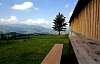
| Wittelsbacher Höhe |

322.00 KB
1024 x 680
|

307.51 KB
1024 x 680
|

307.15 KB
1024 x 680
|
311.00 KB
1024 x 680
|

381.87 KB
1024 x 680
|

256.41 KB
1024 x 680
|
380.78 KB
1024 x 680
|

264.94 KB
1024 x 680
|

192.53 KB
1024 x 680
|

299.46 KB
1024 x 680
|

270.38 KB
1024 x 680
|

205.41 KB
1024 x 680
|
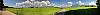
| Panoramen: Wittelsbacher Höhe |

1253.74 KB
4557 x 768
|

1315.46 KB
4085 x 768
|
| Hintersteiner Tal - Giebelhaus |

336.87 KB
1024 x 680
|

227.94 KB
1024 x 680
|

236.90 KB
1024 x 680
|

358.32 KB
1024 x 680
|
283.06 KB
1024 x 680
|

345.76 KB
1024 x 680
|
| Von Sonthofen über die Sattelhütte rund um den Grünten |

98.33 KB
800 x 520
|

66.16 KB
800 x 538
|

92.91 KB
520 x 800
|
58.07 KB
800 x 523
|

280.96 KB
1024 x 680
|
340.24 KB
1024 x 680
|
| Von Sonthofen über die Alpe Straußberg zur Bergstation unterhalb des Imberger Horns |

70.82 KB
800 x 518
|

66.93 KB
800 x 517
|

76.42 KB
800 x 514
|

75.42 KB
800 x 520
|

86.51 KB
800 x 524
|
53.81 KB
800 x 514
|

54.88 KB
800 x 521
|

68.47 KB
800 x 514
|

103.51 KB
556 x 800
|

100.50 KB
800 x 515
|
54.10 KB
800 x 523
|

91.81 KB
800 x 524
|

71.98 KB
800 x 521
|

87.71 KB
800 x 520
|
| Ruine Laubenbergerstein bei Immenstadt |

283.89 KB
1024 x 680
|

298.27 KB
1024 x 680
|

339.39 KB
1024 x 680
|
| Gletscherschliff bei Weiher (ca. 18000 Jahre alt) |

458.25 KB
1024 x 680
|

377.16 KB
1024 x 680
|
| Iller Impressionen |

384.59 KB
1024 x 680
|
265.08 KB
1024 x 680
|

258.03 KB
1024 x 680
|
| Panoramen: Richtung Fischen, Sonthofen |

814.38 KB
2341 x 768
|

833.20 KB
3029 x 768
|

674.59 KB
2276 x 768
|
| Panoramen: Richtung Oberstdorf |

528.87 KB
2312 x 768
|

636.08 KB
2180 x 768
|

406.98 KB
2312 x 768
|

533.85 KB
2312 x 768
|

647.24 KB
2236 x 768
|
| Panoramen: 'Hörnerblick' |

558.23 KB
2312 x 768
|
746.20 KB
3231 x 768
|

730.77 KB
3303 x 768
|

525.96 KB
2686 x 768
|
| Panoramen: Nähe Hörnerbahn Bergstation (Talort Bolsterlang) |

4.73 MB
7046 x 2092
|

9.77 MB
16234 x 2466
|

7.62 MB
12192 x 2647
|
8.49 MB
10900 x 2782
|

5.32 MB
8258 x 2069
|
| Panoramen: Von Winkel Richtung Berghofen |

816.09 KB
3800 x 812
|

1102.29 KB
4000 x 1056
|
| Panorama: bei Margarethen / Sonthofen |
1441.33 KB
5218 x 768
|
|
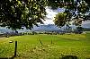
Biken in Bayern - die Osterseen (bei Iffeldorf) |
|

53.92 KB
450 x 600
|

108.46 KB
800 x 600
|

98.58 KB
800 x 600
|

94.01 KB
800 x 600
|

70.82 KB
800 x 600
|

62.68 KB
450 x 600
|

64.64 KB
800 x 600
|

82.84 KB
800 x 564
|

61.48 KB
800 x 558
|

64.59 KB
800 x 558
|

64.82 KB
800 x 600
|

70.46 KB
800 x 600
|

86.70 KB
557 x 800
|

116.22 KB
800 x 600
|
|
Biken in Bayern - Kloster Benediktbeuern |
|
65.43 KB
800 x 600
|

46.83 KB
800 x 447
|

73.42 KB
800 x 600
|
|
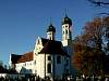
Biken in Bayern - Kochel |
|

65.40 KB
800 x 557
|

85.89 KB
800 x 556
|
| |
|
|
|
|
|
| (c) 2001 - 2025 by Manfred Rausch |
|
|

)
)
)
)
)
)
)
)
)
)
)
)
)
)
)
)
)
)
)
)
)
)
)
)
)
)
)
)
)
)
)
)
)
)
)
)
)
)
)
)
)
)
)
)
)
)
)
)
)
)
)
)
)
)
)
)
)
)
)
)
)
)
)
)
)
)
)
)
)
)
)
)
)
)
)
)
)
)
)
)
)
)
)
)
)
)
)
)
)
)
)
)
)
)
)
)
)
)
)
)
)
)
)
)
)
)
)
)
)
)
)
)
)
)
)
)
)
)
)
)
)
)
)
)
)
)
)
)
)
)
)
)
)
)
)
)
)
)
)
)
)
)
)
)
)
)
)
)
)
)
)
)
)
)
)
)
)
)
)
)
)
)
)
)
)
)
)
)
)
)
)
)
)
)
)
)
)
)
)
)
)
)
)
)
)
)
)
)
)
)
)
)
)
)
)
)
)
)
)
)
)
)
)
)
)
)
)
)